

- Index
- >Projects
- >Projects in progress
- >ECHO-khiES
ECHO-χES Research Project
High-precision exploration and mapping for the observation of bats in underground environments
Group : Dynamic Systems and Optimization
Labelling: none
Duration: from 09/2026 to 09/2028
Funding: Pays de la Loire Region and UA (PULSAR funding)
Staff involved from LARIS: Rafael Accácio NOGUEIRA
Abstract for the General Public
The year is 2065... Weyland Industries, a major space exploration corporation, is developing the “spectagraph,” a device equipped with short-wavelength laser beams that scans an area, creates 3D maps with nanometer-level precision, and provides information about the environment—such as the presence of toxins or ... new forms of life.
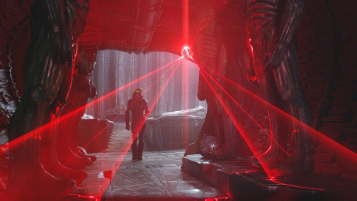
Still from Ridley Scott's film *Prometheus* (2012) showing the “spectagraph,” a device used to map alien caves and count the life forms found there. Copyright: 20th Century Studios.
Although we’re not in 2065, nor in a science-fiction movie, a device like the “spectagraph” could be very useful to us.
On our own planet (or even in our own region!), there are various places that are very difficult for humans to access.
This is particularly true of certain caverns and caves that are not home to unknown aliens, but to known species that are now in danger and must be carefully monitored and protected.
In the Pays de la Loire region, there are various species of bats (known as chiroptera in scientific terms) that take refuge in various underground cavities, such as caves, caverns, and cellars.
The main objective of this project is to map some of the region’s cavities where these animals roost and to count the individuals present, in order to assess the impact of conservation efforts on population growth.
These maps will help various experts better understand the behavior of these animals and will also facilitate navigation within these areas.
In mobile robotics, the problem of localizing and mapping an environment is called SLAM (Simultaneous Localization and Mapping), and it is the scientific focus of this project.
Exploring underground cavities presents several practical and technological challenges:
- First, navigating the study sites is difficult and sometimes requires rock-climbing skills.
- The second challenge stems from the lack of contact with the outside world, which prevents the use of GNSS (satellite-based positioning). It will therefore be necessary to use other means to determine one’s position and to identify which sensors should be used to achieve sufficient resolution—both for positioning and for mapping the environment.
The project’s core scientific objective is multi-agent-guaranteed simultaneous localization and mapping (SLAM) of caves without absolute sensors such as GNSS.
An intermediate/final output of the SLAM algorithms is a map of the environment.
Particular attention will be paid to the noise generated by our movements and to the choice of equipment used (devices such as sonar or the propellers of flying robots could harm the species under study).
For this reason, all phases of the project will be supported by animal welfare organizations that will help us identify the limitations of our methods, so that we can develop robots better equipped to help protect our bat friends.
